
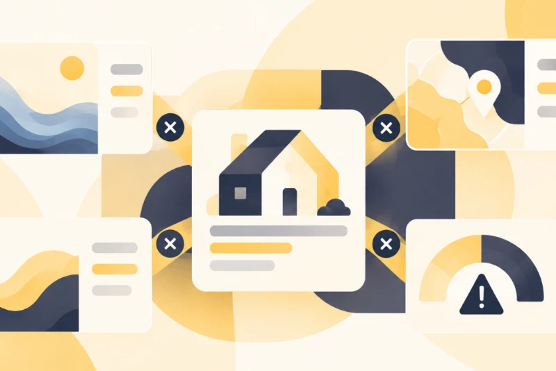
Property risk intelligence is the property-level risk assessment a platform derives by reconciling observations from multiple third-party providers. It is more than a set of provider scores shown side by side.
The challenge begins when those sources describe the same property differently. One may report a modeled flood probability, another a regulatory flood-zone designation, and another a physical characteristic that affects exposure. They may also use different dates, geographic units, methodologies, and scoring systems. Reconciliation is the layer that keeps those differences explicit, determines which observations can be compared, and derives an assessment without treating unlike measurements as interchangeable.
One provider flags a property as high flood risk, another rates it moderate, and a third holds the record under a slightly different address. Left unresolved, that is the view an analyst is asked to trust.
The connectors are only part of the problem. The harder engineering challenge comes after ingestion: determining how observations about the same property differ in meaning, timing, geographic scope, and methodology before they reach underwriting or analytics.
Why More Property Risk Data Does Not Automatically Create Better Intelligence
Adding another provider can expand coverage, but it can also introduce another methodology, scoring scale, geographic resolution, or update cycle. More observations do not become better intelligence simply because they are stored in the same platform.
For risk data, four questions need to stay separate:
- Identity: Do the observations refer to the same property?
- Meaning: Are they measuring the same risk concept?
- Context: Do their dates, geographic scopes, and methodologies make them comparable?
- Reconciliation: Given those differences, what should the platform retain, compare, qualify, or derive?
The first question is a prerequisite. The last three are where most of the reconciliation problem begins.
Another API connection expands the available evidence, but it does not determine how conflicting observations should relate to one another. The platform needs explicit reconciliation logic to account for differences in meaning, timing, geographic scope, and methodology before deciding what to retain, compare, qualify, or derive.
On The Innovation Blueprint podcast, Joe Stockton of Oyster Data described the same shift among larger operators, who are moving away from one-to-one integrations and treating structured data as modern data infrastructure rather than a backend concern.
Where Third-Party Property Risk Data Conflicts
Once observations have been associated with the correct property, the harder question is whether they can be meaningfully compared. Disagreement usually comes from three dimensions: what is being measured, when it applies, and where it applies. Identity still matters, but primarily as a prerequisite for the reconciliation step.
| Question | What it establishes | Example |
| What is measured? | The concept behind the value | Flood zone, modeled probability, or expected loss |
| When does it apply? | Observation and effective timing | Current model vs. two-year-old assessment |
| Where does it apply? | Geographic and spatial scope | Building, parcel, tract, or hazard zone |
Two observations can refer to the same property and still not be directly comparable. A reconciliation layer has to preserve that distinction rather than flattening every value into a common field.
A public example shows how far two credible sources can diverge on the same hazard. A January 2025 Consumer Financial Protection Bureau analysis compared FEMA flood maps with First Street Foundation data across the U.S. southeast and central southwest, and the two measures identified very different sets of at-risk properties:
- FEMA flood maps: retrospective and focused mostly on coastal flooding, tied to the Special Flood Hazard Areas used to set insurance requirements.
- First Street Foundation: flagged roughly 2.4 times as many mortgaged homes with inland flood risk, using a forward-looking model that accounts for rainfall and a changing climate.
In those regions alone, the CFPB estimated more than 400,000 mortgaged homes may be underinsured because the two sources disagree on exposure. The difference reflects what each dataset is designed to measure, so the outputs should not be treated as interchangeable scores.
Geographic Scope and Observation Timing
Two observations can describe the same property and still represent different slices of risk.
Spatial scope varies. One observation may describe a building footprint, another a parcel, and another a census tract or hazard zone. A risk value calculated for a census tract does not necessarily describe the risk of an individual building within it.
Timing creates another distinction. Observation date, effective date, and last-update date can differ, and a 2022 assessment is not directly interchangeable with a 2025 one. A reconciliation model therefore needs to retain both spatial and temporal context before deciding whether values can be compared or combined.
Methodology, Definitions, and Risk Scoring
Providers can use different source datasets, model inputs, thresholds, definitions, and calibration methods, so identical labels do not necessarily represent comparable levels of risk.
Wildfire scoring shows the pattern: platforms commonly license proprietary scores such as Verisk’s FireLine, ZestyAI’s Z-FIRE, and CoreLogic’s wildfire score, which draw on different inputs and different scales (some 1 to 10, some 1 to 100). A high from one cannot be mapped to a high from another without accounting for the definitions behind them.
Semantic normalization has to respect those differences rather than flatten them. Labels that sound alike can measure different things:
- Flood zone: a regulatory designation.
- Modeled flood probability: a modeled likelihood.
- Expected annual loss: a dollar estimate.
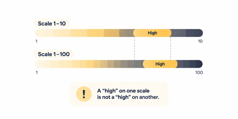
One generic “flood risk” field cannot represent all three, and merging them discards information a downstream model may need. On the same podcast, Bob Frady, co-founder of PropertyLens, described the real difficulty with property risk data: collecting any single dataset is straightforward, but getting independently built databases to stay consistent and work together is the hard part. That is where most of the reconciliation engineering goes, separate from connecting to each provider.
Why Reconciliation Is the Core Engineering Problem
Reconciliation is the logic that determines how multiple observations for the same property are compared, retained, qualified, weighted, or transformed into a derived, property-level assessment, with the reasoning kept traceable. It is more involved than choosing a provider or averaging scores.
Simple rules tend to break down:
- “Provider A always wins” can be brittle. A provider may be preferred for one attribute or geography while another has better coverage, recency, or methodology elsewhere.
- Reconciliation is not averaging. When two providers measure different concepts, the output may preserve both observations, classify their relationship, and expose the disagreement rather than manufacture a composite number.
- Disagreement can be the output. Sometimes the derived result is not a single score, but an assessment paired with a disagreement state, supporting quality indicators, or a review flag, which can itself be decision-relevant in an investment context.
The response depends on the situation:
| Situation | Reconciliation response |
| Same property, same concept, different dates | Compare or prefer using recency and effective-date rules |
| Same property, different geographic units | Preserve scope rather than compare values directly |
| Same label, different methodology | Keep the methodologies distinct |
| Comparable sources, different values | Apply defined source and attribute rules |
| Sources measure different concepts | Retain both as separate signals |
| Insufficient context to compare | Flag for review rather than force a result |
Build a Context-Aware Reconciliation Model
A reconciliation layer works on contextualized observations rather than overwriting source values. Its rules can account for source coverage, geography, observation timing, methodology, attribute type, known data-quality characteristics, and any confidence measures available from the source or the platform. Rules that are explicit, testable, and versioned stay maintainable as sources change.
A compact example: two providers report flood risk for one property.
- Provider A rates it high, using current-climate precipitation modeling at the parcel level, dated this year.
- Provider B rates it moderate, using a regulatory flood-zone definition mapped two years ago at a coarser resolution.
A context-aware layer can retain both, record that they measure related but different things, and derive a qualified assessment, such as elevated with source disagreement flagged, without discarding either input.
Preserve Provenance and Confidence
A derived assessment should stay traceable to the observations behind it. In practice, that requires storing, for each contributing observation:
- source or provider, and the source-specific identifier
- observation, effective, and update dates
- geographic scope and spatial unit
- methodology or model version, where available
- the reconciliation rule applied
- a confidence indicator and the transformation history
Confidence can come from provider-supplied uncertainty measures, data-quality checks, reconciliation outcomes, or platform-specific validation, and it should not be read as a single universal score across providers.
An operational test is simple: can an analyst see why the platform produced this assessment for this property?
If that reasoning cannot be reconstructed from the stored observations and rules, the assessment is hard to validate or defend in an underwriting workflow.
From Source Observations to Derived Property Risk Intelligence
External providers supply observations, measurements, and sometimes already-derived scores. The platform’s role is to contextualize those inputs and produce an assessment consistent with its own product logic. A clear vocabulary keeps the layers distinct:
- Source observations: the original provider-level values.
- Contextualized observations: those values with their date, geography, and methodology attached.
- Derived assessment: the platform’s reconciled output for a risk attribute.
- Property risk intelligence: the product layer built around those assessments.
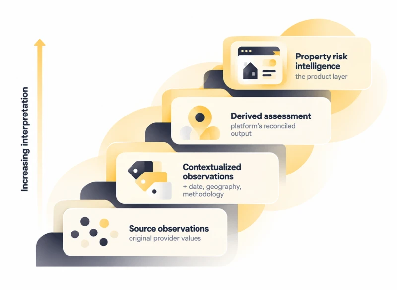
The derived assessment is the platform’s interpretation, an output of its own reconciliation logic rather than a value handed over by one provider, which is why its provenance stays attached.
What the Property Risk Intelligence Layer Should Represent
Rather than prescribing one universal schema, it helps to define what the layer represents for any property.
| Layer | What it stores | Why it matters |
| Observation | Each provider’s value, with its attribute and source | Keeps conflicting inputs side by side |
| Context | Date, geography, spatial unit, methodology | Makes observations comparable |
| Reconciliation | Rule and version, plus assessment status | Records how the derived value was produced |
| Provenance | Source lineage and transformation history | Lets the assessment be reconstructed |
When exposed through APIs and product interfaces, this layer can feed embedded analytics and operational workflows, so an analyst sees a derived assessment and its supporting evidence together.
Example: Reconciling Conflicting Risk Data for One Property
Consider one hypothetical property with three inputs from three providers.
| Source | Type | Observation | Spatial unit | As of | Role |
| Provider A | Flood model | High (8/10) | Parcel | This year | Modeled risk |
| Provider B | Regulatory mapping | Within a moderate flood zone | Flood zone | 2-year-old map | Regulatory context |
| Provider C | Elevation data | Finished floor ~2 ft above base flood elevation | Building | Survey date | Physical context |
The engineering chain runs as follows:
1.The three inputs are associated with the same property despite two address formats and one parcel ID.
2.Contextual comparison notes that A and B measure related but different things, a modeled probability and a regulatory zone, at different resolutions and dates, and that C is a physical characteristic rather than a flood-risk score.
3.Reconciliation rules retain A and B as distinct flood-risk observations and use C as physical context that may affect interpretation, where the underlying methodology supports doing so, while flagging the A and B disagreement.
4.Provenance records all three inputs, their dates, methods, and the rule applied.
The result can be a derived assessment an analyst can open, question, and trace, without forcing the platform to select one provider as universally authoritative.
Engineering the Reconciliation Layer
Reconciliation does not replace the underlying property data architecture. It adds a decision layer between contextualized source observations and the product’s derived assessment.
A practical flow is:
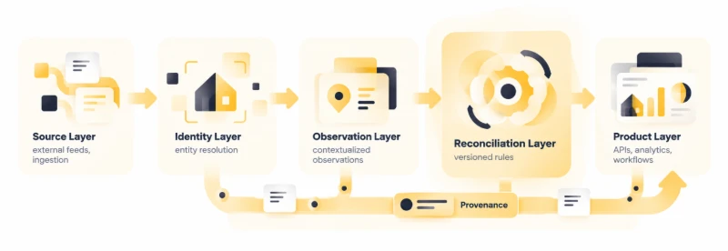
The property identity is established upstream. The reconciliation layer then works with observations that are already associated with the relevant property and focuses on how those observations relate.
Two design decisions matter most:
Preserve source observations. Never overwrite provider values simply to create a cleaner output. The original observation, methodology, timing, and scope are part of the evidence.
Version reconciliation rules. A provider can change its methodology, a source can become more current, or product requirements can change. Versioned rules allow the platform to explain why an assessment changed rather than silently replacing historical logic.
This separation also makes new risk providers easier to incorporate. A new source adds observations to the same reconciliation framework rather than requiring downstream products to interpret another provider-specific output independently.
How Reconciled Risk Intelligence Supports Underwriting and Investment Workflows
Reliable inputs matter here because risk data increasingly feeds capital decisions. A June 2026 NAIOP Research Foundation report found that institutional investors, lenders, and insurers are increasingly building forward-looking physical-risk analytics into underwriting, alongside historical loss data and resilience assessments. That shift raises the value of inputs that are consistent and traceable rather than pulled together ad hoc from conflicting sources.
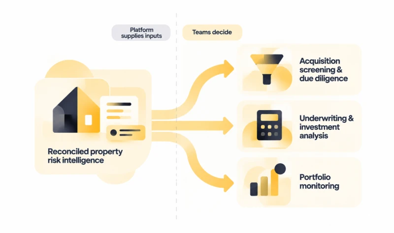
One boundary is worth stating plainly. The platform architecture can preserve and reconcile the inputs, while the domain methodology stays with the relevant provider, client, or investment team.
Acquisition Screening and Due Diligence
During screening, a reconciled layer gives analysts a more consistent starting point across a pipeline of properties, and it lets them investigate conflicting observations in place rather than comparing disconnected provider outputs by hand. That connects naturally to the investment intelligence tooling acquisition teams already use.
Underwriting and Investment Analysis
Structured, qualified risk inputs can feed underwriting models, scenario analysis, and property valuation models, including automated valuation models (AVMs). The separation holds: the data platform supplies inputs with their provenance and confidence, and the financial models and investment teams decide how those inputs influence pricing and allocation.
Portfolio Monitoring
After acquisition, retained observations, timestamps, and source metadata support ongoing monitoring. When a provider updates a score or changes a methodology, a platform that preserves historical observations and that metadata can detect relevant changes and show what moved and why, rather than silently overwriting the prior value.
What Happens When Property Risk Data Is Not Reconciled
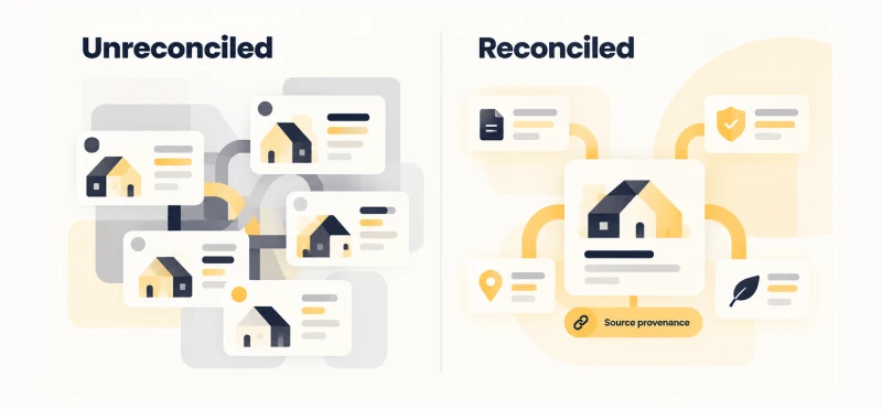
Without a dedicated reconciliation layer, a platform may:
- treat different risk concepts as if they were the same measurement
- combine scores that use incompatible scales or methodologies
- present an area-level observation as if it described the property itself
- use a newer observation without accounting for differences in effective date
- discard source context when creating a canonical value
- hide meaningful disagreement behind a single composite score
- leave analysts to interpret conflicting provider outputs manually
These are not simply integration problems. The sources may already be connected and the records may already be associated with the correct property. The unresolved problem is what those observations mean together and how the platform should represent that relationship.
Engineer a Property Risk Intelligence Layer
The number of property-risk feeds a platform can reach keeps growing. That expands the evidence available to a product, but it also increases the number of differences the platform has to interpret.
The engineering challenge is not simply connecting another provider. It is preserving each observation’s meaning, determining which observations can be compared, and encoding explicit rules for how disagreement should affect the derived assessment.
Handled that way, reconciliation becomes durable product infrastructure. New providers, new risk dimensions, and changing methodologies can feed the same framework without forcing downstream teams to interpret every source independently.
For underwriting and investment teams, the practical goal is not a single “true” risk score. It is a property-level assessment that is consistent enough to use, transparent enough to investigate, and traceable enough to understand when the underlying evidence changes.


